Saturday, October 18, 2008

Tootling around the Back Roads - Oct 18, 2008


A little late for the best of the autumn color, but an interesting drive nonetheless. Hampton to the Ravine Road, then indirectly to somewhere on the Bellisle, then to Springfield, then up an unknown road network to some very high hills overlooking the Sussex Valley, finding our way to Pearsonville, and the Irish Settlement Road and eventually back to the "old" TCH to Sussex then back home via the "old" road on the North side of the Kennebecasis.

From a photography point of view, the late afternoon fall light is quite lovely, though the bright sun is helped along quite a bit when one remembers the polarizing filter in the kitbag.

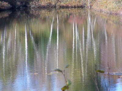
Blueberries are grown commercially in this area, and this a about the best time of year to see the fields in autumnal glory. The reds in the forests are gone now, and the rusts of oak and beech are coming into their own. Reflections are still a favorite of mine to search out and experiment with.

Friday, October 17, 2008

Rockwood Park, Saint John, NB - October 15, 2008

From Rockwood Park October 08


Rockwood Park is a gem in the midst of urban Saint John: acres of wooded rocky ground, lakes and walking trails of varying degree of difficulty. Part of the gem is that some beautiful parts of the park are very accessible by vehicle and/or wheelchair.

The pictures here, were taken within a 5-minute walk from the car, in the most accessible region of the park -- mid October 2008.


Sunday, October 14, 2007

Backroads to Sussex

Today's road trip found us taking the Bonny Road at Nauwigewauk, then on to Smithtown and Titusville. We took a back road toward Sussex, ending up in Sussex Corner, from whence we took the Parlee Brook Road literally into the woods. This is a great road for leaf viewing as it is very narrow and you can get up close and personal with the scenery. It was a little sunny for good pictures, but the trip was well worth it regardless.

Being unable to get up a hill due to a very wet muddy road, we detoured and ended up in Waterford. The shots showing a stream with red trees in the foreground and in the distance are from the bridge at Waterford. You can park beside a large white building just past the bridge, and take a path down under the bridge to see an amazing waterfall and rock formations. At the bottom, a side-stream enters and the view is remarkable any time of year.


See more NB Autumn: French Village Road

-----------------------------------------

Norton Shore Road, Hampton, Backyard

This is an attempt to connect PhotoBucket slideshows with this blog.
It may or may not work. If it does, these are recent photos from Southern NB in the Hampton area.

You can stop the slide by mousing in the lower right area. The little square stops the current slide.


Thursday, October 4, 2007

Grand Manan - August 2007

How remiss I have been getting back to this blog. I guess discipline is not my major trait.

Our Grand Manan trip was a 2-day venture with our 8-year-old grandson, who was thrilled with the ferry, and pretty much every other aspect of the trip.

Below is a link to a photo album for the trip, with most of the views at roadside, or nearby.


http://www.flickr.com/photos/bettyfleet/sets/72157602016460489/

We found a delightful combination of sun and fog, terrific, friendly people, a motel right on the beach, and lots of space to walk and feel connected to the earth and the sea. The Sardine Museum, with its history of the salt herring industry was a fascinating way to spend a rainy morning.

Saturday, August 11, 2007

Waiting for the Grand Manan Ferry


I always view waiting as an opportunity, not a bother. There is always something to look at, something new to see.

Recently, we took our grandson to Grand Manan for an overnight visit. It was his first trip on a car ferry, and we arrived early to be assured of a spot. It was a dingy day, a bit misty and quite chilly -- a little dark at first for good photos. Nonetheless, an exploration of the nearby docks, and the beach adjacent to the parking lot provided exciting camera fodder for the hour wait.

Of special interest was a patch of periwinkle shells on the beach, beautiful yellow flowers still covered in fog, and the usual views of the Fundy Coast found anywhere in this area. As well, a scraggly patch of fireweed bloomed in the midst of a host of other plants including raspberries, red currants, evening primrose and some white-flowered vines which I cannot identify.

Returning from my amazement of at least a dozen species in this one little patch of bushes beside the parking lot, I met a couple from Florida who had just arrived. They seemed surprised to see me emerging from the beach with my camera at the ready, and asked, "Is there something down there?" I knew they were not referring to my seashells, fireweed and the gentle roll of the ocean swell against the rocks. "Oh, yes," I said, "It's the Fundy Coast," but they didn't turn, or even look in that direction. So much is missed when looking for "something."

Grand Manan proved a photographer's dream, but that is another posting. For now, wait with me for the ferry.

Thursday, August 2, 2007

Side Trip - Waterfall Erb's Cove

It's great fun seeking out waterfalls, especially those hidden close to the roadside. This one is less than a 2-minute walk from the roadside. When the water flow is not too heavy, you can climb out onto the various rock formations to get really close to the action.

These pictures show a waterfall near Erb's Cove on the Bellisle River. They were taken on two different dates, one in early spring before the leaves have come out, and one later when the woods are in full spring greenery.

It's a small waterfall, with an old concrete fish ladder along one side. This is in farming country, and is undoubtedly on private property. However, there seems to be a well-worn trail, and often people are seen fishing there.

The bridge crossing the stream offers a pleasant view of the stream, but only a hint of the waterfall below.

Connecting to my Picasa albums allows you to see the pictures in a larger format slideshow, and/or to see the locations mapped by Google Maps and Google Earth.